geo_point_in_circle()
Calculates whether the geospatial coordinates are inside a circle on Earth.
Syntax
geo_point_in_circle(p_longitude, p_latitude, pc_longitude, pc_latitude, c_radius)
Parameters
| Name | Type | Required | Description |
|---|---|---|---|
| p_longitude | real | ✔️ | Geospatial coordinate longitude value in degrees. Valid value is a real number and in the range [-180, +180]. |
| p_latitude | real | ✔️ | Geospatial coordinate latitude value in degrees. Valid value is a real number and in the range [-90, +90]. |
| pc_longitude | real | ✔️ | Circle center geospatial coordinate longitude value in degrees. Valid value is a real number and in the range [-180, +180]. |
| pc_latitude | real | ✔️ | circle center geospatial coordinate latitude value in degrees. Valid value is a real number and in the range [-90, +90]. |
| c_radius | real | ✔️ | Circle radius in meters. Valid value must be positive. |
Returns
Indicates whether the geospatial coordinates are inside a circle. If the coordinates or circle is invalid, the query produces a null result.
Examples
The following example finds all the places in the area defined by the following circle: Radius of 18 km, center at [-122.317404, 47.609119] coordinates.
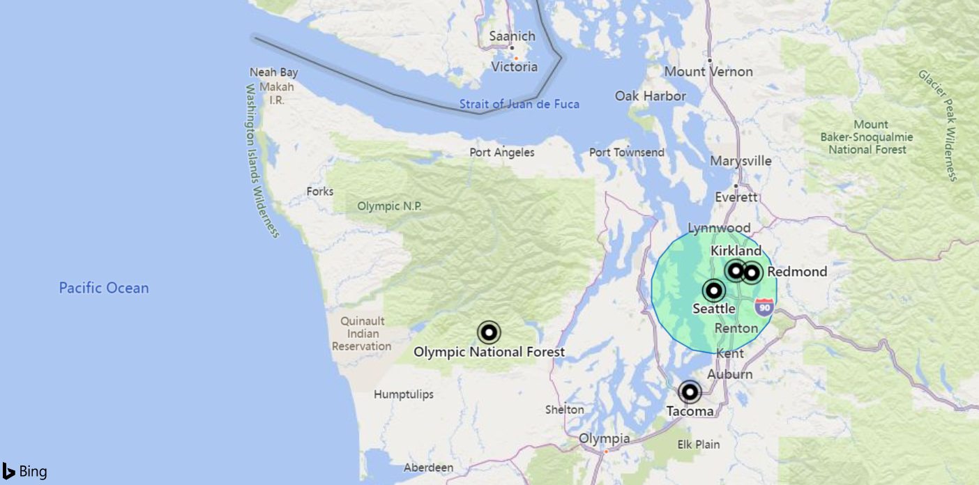
datatable(longitude:real, latitude:real, place:string)
[
    real(-122.317404), 47.609119, 'Seattle',                   // In circle
    real(-123.497688), 47.458098, 'Olympic National Forest',   // In exterior of circle
    real(-122.201741), 47.677084, 'Kirkland',                  // In circle
    real(-122.443663), 47.247092, 'Tacoma',                    // In exterior of circle
    real(-122.121975), 47.671345, 'Redmond',                   // In circle
]
| where geo_point_in_circle(longitude, latitude, -122.317404, 47.609119, 18000)
| project place
Output
| place |
|---|
| Seattle |
| Kirkland |
| Redmond |
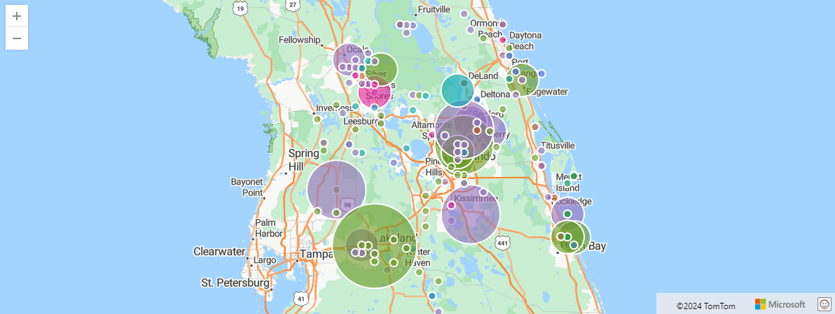
The following example finds storm events in Orlando. The events are filtered by 100 km within Orlando coordinates, and aggregated by event type and hash.
StormEvents
| project BeginLon, BeginLat, EventType
| where geo_point_in_circle(BeginLon, BeginLat, real(-81.3891), 28.5346, 1000 * 100)
| summarize count() by EventType, hash = geo_point_to_s2cell(BeginLon, BeginLat)
| project geo_s2cell_to_central_point(hash), EventType, count_
| render piechart with (kind=map) // map pie rendering available in Kusto Explorer desktop
Output
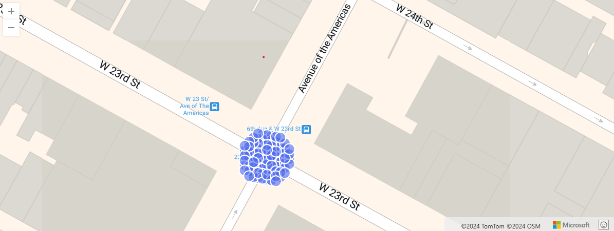
The following example shows New York city taxi pickups within 10 meters of a particular location. Relevant pickups are aggregated by hash.
nyc_taxi
| project pickup_longitude, pickup_latitude
| where geo_point_in_circle( pickup_longitude, pickup_latitude, real(-73.9928), 40.7429, 10)
| summarize by hash = geo_point_to_s2cell(pickup_longitude, pickup_latitude, 22)
| project geo_s2cell_to_central_point(hash)
| render scatterchart with (kind = map)
Output
The following example returns true.
print in_circle = geo_point_in_circle(-122.143564, 47.535677, -122.100896, 47.527351, 3500)
Output
| in_circle |
|---|
| true |
The following example returns false.
print in_circle = geo_point_in_circle(-122.137575, 47.630683, -122.100896, 47.527351, 3500)
Output
| in_circle |
|---|
| false |
The following example returns a null result because of the invalid coordinate input.
print in_circle = geo_point_in_circle(200, 1, 1, 1, 1)
Output
| in_circle |
|---|
The following example returns a null result because of the invalid circle radius input.
print in_circle = geo_point_in_circle(1, 1, 1, 1, -1)
Output
| in_circle |
|---|
Feedback
Was this page helpful?
Glad to hear it! Please tell us how we can improve.
Sorry to hear that. Please tell us how we can improve.